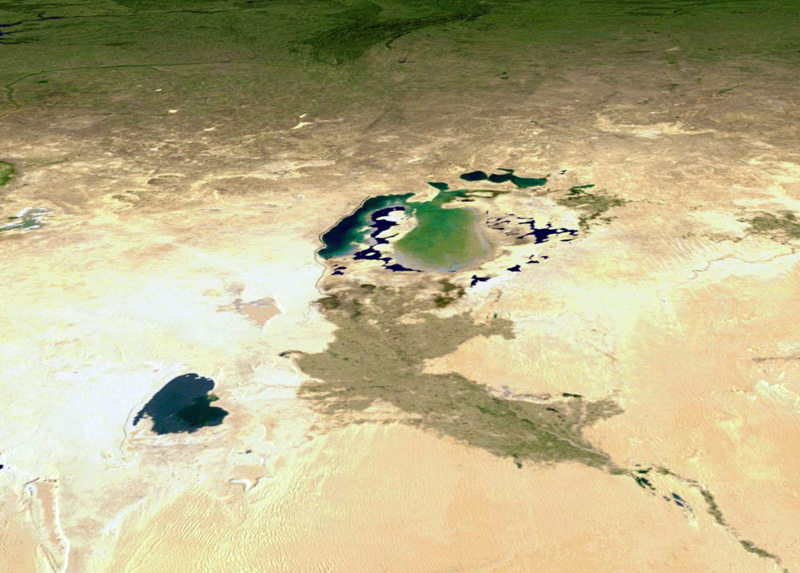
This was once the shoreline of the Aral Sea
The incredible, shrinking Aral Sea (Арал теңізі, Aral Tengizi, Orol dengizi, Аральскοе мοре) is a landlocked sea--really a lake--in Central Asia, lying between between Kazakhstan and Uzbekistan in the middle of a semi-arid and desert region. It is/was generally a very shallow lake with a maximum depth of only 180 feet.
Since the 1960s the Aral Sea has been shrinking as the rivers that feed it (the Amu Darya and the Syr Darya) were diverted for irrigation purposes. In addition, what is left of the Aral Sea is heavily polluted from fertilizer run-off, industrial discharges and even weapons testing residue. The result of the "sea shrinkage" is an environmental and economic disaster. (The Aral Sea problem is much covered on the web, and you can find plenty of images and information.)
Dating back to the early years of the Bolshevik regime, the government wanted to use the Amu Darya and the Syr Darya Rivers to irrigate the Central Asian desert, hopefully to expand agriculture, especially the cultivation of cotton which could then be exported for cash. It was under Stalin in the 1930s that irrigation canals began to be dug. These canals, such as the Qaraqum (Karakum) Canal, the largest in the world, were greatly expanded through the 1950s.
That is when the trouble started. By the 1960s a significant portion of the inflow to the Aral Sea had been diverted, and the Sea began to shrink--what made the situation even worse was the fact that because of the poor construction of the irrigation canals anywhere from thirty to seventy percent of the canal water leaked out and was wasted.
By the 1980, there were two "Aral Seas," the North Aral Sea and the South Aral Sea.
- As the Sea got smaller, the salinity doubled, which ended the commercial fishing trade. By the 1980s, some fish populations were bordering on extinction.
- Another effect of the reduction in the Aral Sea’s size was the rapid exposure of the lake bed. Strong winds that blow across the exposed seabed pick up and deposit tens of thousands of tons of toxic clay and salt. This has lead to health problems for nearby residents--life expectancies near the sea are much lower than those in surrounding areas--and lowered crop yields as the toxic dust falls on, and contaminates, arable land.
- The smaller Sea has also had an effect on the region's climate as the moderating influence of the large lake is now gone. The growing season around the Aral Sea is shorter, causing many farmers to switch from cotton to rice, which demands even more irrigation water.
Future efforts regarding the Aral Sea seem to be focusing on the reality of the existence of the two "seas."
For the North Aral Sea, some irrigation works along the Syr Darya have been fixed and a concrete dam was built to separate the two halves of the Aral Sea. With the completion of the dam, the water level of the North Aral has risen, and its salinity has decreased.
The fate of the South Aral Sea appears to be more problematic. It is still vanishing, although every once in a while the dam separating the two halves is opened so that water can flow to the south. The South Aral Sea has even been divided further into eastern and western parts, with the western expected to be gone within fifteen years.
As, if that was not enough of a problem! Since the early 1950s, the Soviet Union had maintained a top secret bio-weapons facility on the island of Vozrozhdenie in the middle of the Aral Sea--well, it used to be an island. At the facility, it is now clear that Soviet scientists developed weapons-grade pathogens and conducted open-air testing of virulent bacteria such as anthrax, plague, small pox and others.
"In 1992, Kanatjan Alibekov, a senior Soviet bio-weapons scientist, defected to the United States and revealed that weaponized anthrax had been buried on Vozrozhdeniye Island. The U.S. intelligence community was able to determine the locations of the burial sites from historical satellite images taken while the pits were being dug. A Department of Defense team then traveled to the island and took soil samples, which revealed the presence of viable spores of weaponized anthrax." (Source: cns.miis.edu/pubs/dc/briefs/011802.htm)
Evacuation of Russian personnel from the island began in 1991. Then, in August 1995, specialists from the US visited the island and confirmed that the the site's infrastructure had been destroyed.
Brian Hayes, a biochemical engineer with the Pentagon's Threat Reduction Agency, led an expedition in the spring and summer of 2002 to neutralize what was likely the world's largest anthrax dumping grounds. His team of 113 people neutralized between 100 and 200 tons of anthrax over a three-month period. The cost of the cleanup operation was approximately $5 million.

Postscript
For some truly dramatic imagery from 1973, 1987, 2002 that shows the shrinking of the Aral Sea as seen from Landsat photographs, source was NASA Earth Observatory.
Then for something a bit surprising, check the images on the NASA Earth Observatory possibly indicating Aral Sea expansion? from 2005 and 2006, which appear to indicate that the Northern Aral Sea is re-filling faster than expected.